Toronto, Ontario--(Newsfile Corp. - March 20, 2023) - Appia Rare Earths & Uranium Corp. (CSE: API) (OTCQX: APAAF) (FSE: A0I0) (FSE: A0I0.F) (FSE: A0I0.MU) (FSE: A0I0.BE) (the "Company" or "Appia") is excited to announce the release of geochemical assay results from 2022 diamond drilling of the Magnet Ridge Zone on its 100%-owned Alces Lake Rare Earth Elements (REES) Property, Northern Saskatchewan.
Final assays for Appia's 2022 Alces Lake diamond drilling program have been received, compiled, and interpreted zone-by-zone. The second set of results is reported here. Further results will follow once all the results are finalized.
Highlights from the Magnet Ridge drilling program (Table 1) are listed as follows:
- Drilling intersected thick sequences of REES from surface to 85 meters depth, with drilled widths up to 28.19 meters.
- The discovered mineralization intervals are similar in nature and larger in size when compared to the AMP Zone at WRCB.
- Total rare earths oxide (TREO) assays of up to 0.65 wt.% (6500 ppm) TREO were returned, with thickness and grades increasing by >50% to the south-southeast; all within 85 meters of surface.
- 19.85m @ 0.317 wt.% TREO including 8.94m @ 0.467 wt.% TREO in hole 22-AUG-031
- 18.67m @ 0.245 wt.% TREO including 9.02m @ 0.344 wt.% TREO in hole 22-AUG-030
- 26.70m @ 0.246 wt.% TREO including 6.08m @ 0.305 wt.% TREO in hole 22-AUG-013
- 28.19m @ 0.190 wt.% TREO including 3.07m @ 0.506 wt.% TREO in hole 22-AUG-026
- Follow-up drilling is warranted.
In 2022, the Company drilled the Magnet Ridge (formally Augier) prospect (located SSE of WRCB, Figure 1) for the first time and intersected REE mineralization in 27 of 34 DDHs near surface over significant strike length and drilled widths exceeding 28 metres (Figures 2 and 3, Table 1). Table 1 below highlights the most significant geochemical assay results from the Magnet Ridge Zone. Table 2 provides the collar information for all of the drill holes from the 2022 Wilson and AMP (WRC) diamond drilling program. The complete assays results are available in Table 3 by clicking on this link.
The Magnet Ridge zone was discovered from interpreted results of a 2021 airborne radiometric (U-Th-K) survey (Figures 1 and 4), and is exposed on surface as a large 500m long and 150m wide zone of thorium enrichment (Figure 2) along the same km-scale SSE-trending structural corridor hosting the monazite-rich REE zones of the WRCB area (Figures 1 and 4). Mineralization at Magnet Ridge remains open to the SSE and to the NNW for follow-up drilling in 2023. Radiometric Thorium (Th) is an important proxy for delineating monazite mineralization at Alces Lake. A representative X-section (Figure 3) suggests that the structural geometry of the mineralization is complex and probably folded.
Vice President of Exploration Irvine Annesley says "The Company is excited that our very first drilling program at Magnet Ridge yielded these highly anomalous results. Like the WRCB area's AMP zone, the mineralization style/type at Magnet Ridge opens new potential for large-volume, high-tonnage REE deposits over significant strike-length at Alces Lake".
Comprehensive interpretation and modeling of the WRCB and Magnet Ridge mineralized zones have indicated that follow-up geophysical and geochemical surveys (e.g., Figure 4) are necessary along and across the highest-priority areas of a major structural corridor that extends south-southeast from the main mineralized zones at WRCB to Magnet Ridge and then for another 20 to 25 km. These surveys will facilitate delineation and mapping of REE mineralized (monazite-bearing) pegmatites and associated glimmerites within this structural corridor to establish new drill targets. The petrophysical characteristics (i.e. density, radiometric, and magnetic properties) of monazite will be maximized as a vectoring tool(s) for finding new targets (i.e. by utilizing leading edge exploration technology like airborne radiometrics/magnetics/3D gravity gradiometer surveys at optimal line spacing/orientation).
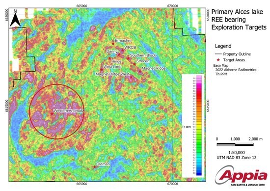
Figure 1. Primary REE-bearing mineralized zones (e.g. WRCB, Magnet Ridge) and exploration targets (Western Anomaly, denoted by red circle) on the Alces Lake REE exploration property.
To view an enhanced version of this graphic, please visit:
https://images.newsfilecorp.com/files/5416/159075_80a5cd0f0461594a_001full.jpg
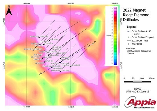
Figure 2. Map of 2022 diamond drill holes (DDHs) in the Magnet Ridge area. Map base illustrates the near-surface equivalent Thorium (Th) abundances as determined by the 2021 airborne radiometric survey. Th is an important pathfinder element (i.e., a proxy to monazite mineralization) at Alces Lake.
To view an enhanced version of this graphic, please visit:
https://images.newsfilecorp.com/files/5416/159075_80a5cd0f0461594a_002full.jpg
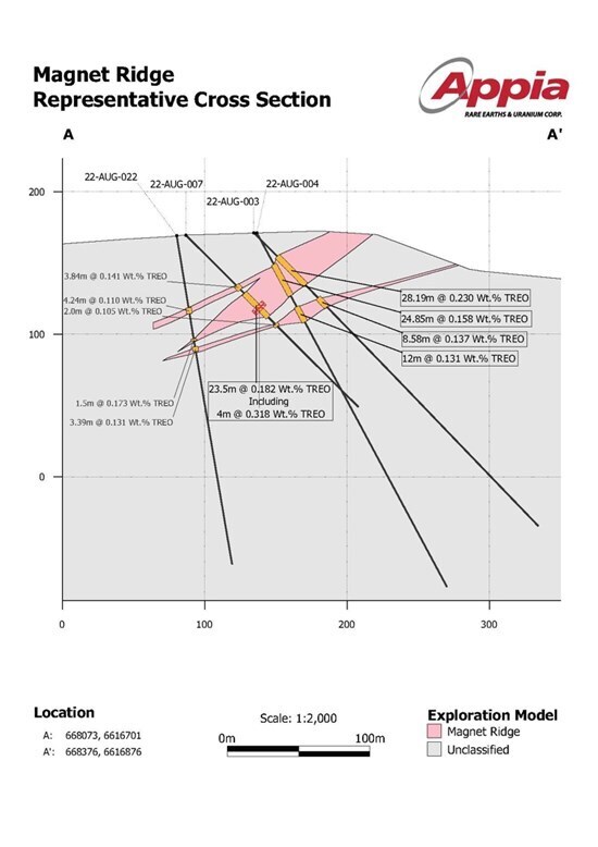
Figure 3. A representative Cross Section of DDHs 22-AUG-003, 22-AUG-004, 22-AUG-007, and 22-AUG-022 from the Magnet Rdge Zone. Vertical 10m thickness section looking 150 degrees.
To view an enhanced version of this graphic, please visit:
https://images.newsfilecorp.com/files/5416/159075_80a5cd0f0461594a_003full.jpg
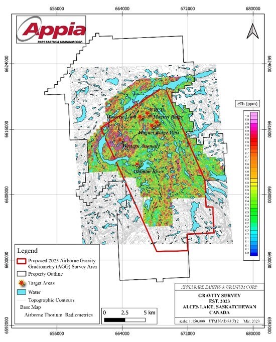
Figure 4. Topography map (overlain by airborne radiometrics equivalent Th) that shows the planned 3D airborne gravity survey area for the 2023 Alces Lake exploration season. This area will also be the focus of aggressive ground prospecting, followed up by selective drilling of priority targets.
To view an enhanced version of this graphic, please visit:
https://images.newsfilecorp.com/files/5416/159075_80a5cd0f0461594a_004full.jpg
Table 1. Summary of Highlighted Drillhole Composites
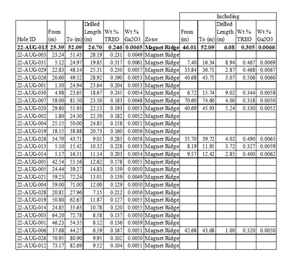
Table 1. Highlighted assay composites from 2022 diamond drillholes in the Magnet Ridge Area. wt.% TREO = ([CeO2 ppm] + [Dy2O3 ppm] + [Pr6O11 ppm] + [La2O3 ppm] + [Nd2O3 ppm] + [Sm2O3 ppm] + [Eu2O3 ppm] + [Gd2O3 ppm] + [Tb4O7 ppm] + [Ho2O3 ppm] [Er2O3 ppm] + [Yb2O3 ppm] + [Lu2O3] ppm + [Y2O3 ppm] ) / 10000
To view an enhanced version of this graphic, please visit:
https://images.newsfilecorp.com/files/5416/159075_table%201%20unresized.jpg
Table 2 - Drill hole collar details for 2022 Magnet Ridge drilling, including those of reported intercepts.
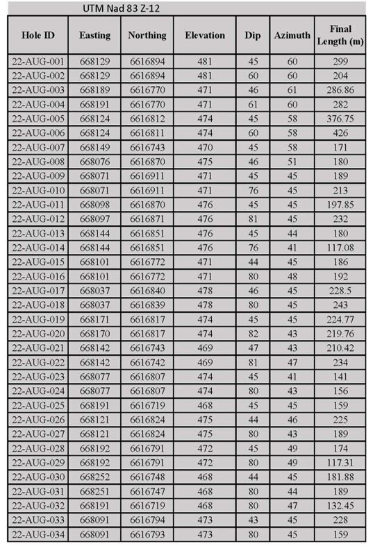
Table 2
Cannot view this image? Visit:
https://images.newsfilecorp.com/files/5416/159075_table%202%20unresized.jpg
Table 3 - The complete assays results are available by clicking on this link. About the Alces Lake Project
The Alces Lake project encompasses some of the highest-grade total and critical* REEs and gallium mineralization in the world, hosted within several surface and near-surface monazite-bearing occurrences that remain open at depth and along strike.
* Critical rare earth elements are defined here as those that are in short-supply and high-demand for use in permanent magnets and modern electronic applications such as electric vehicles and wind turbines (i.e: neodymium (Nd), praseodymium (Pr), dysprosium (Dy) and terbium (Tb)).
The Alces Lake project is located in northern Saskatchewan, the same provincial jurisdiction that is developing a "first-of-its-kind" rare earth processing facility in Canada (currently under construction by the Saskatchewan Research Council and scheduled to become fully operational in early 2024). The Alces Lake project area is 38,522.43 contiguous hectares (95,191.00 acres) in size and is 100% owned by Appia.
All lithogeochemical assay results of core samples were provided by Saskatchewan Research Council's Geoanalytical Laboratory, an ISO/IEC 17025:2005 (CAN-P-4E) certified laboratory in Saskatoon, SK. All analytical results reported herein have passed internal QA/QC review and compilation.
The technical content in this news release was reviewed and approved by Dr. Irvine R. Annesley, P.Geo, Vice-President Exploration, and a Qualified Person as defined by National Instrument 43-101.
About Appia Rare Earths and Uranium Corp (Appia)
Appia is a publicly traded Canadian company in the rare earth element and uranium sectors. The Company is currently focusing on delineating high-grade critical rare earth elements and gallium on the Alces Lake property, as well as exploring for high-grade uranium in the prolific Athabasca Basin on its Otherside, Loranger, North Wollaston, and Eastside properties. The Company holds the surface rights to exploration for 113,837.15 hectares (281,297.72 acres) in Saskatchewan. The Company also has a 100% interest in 12,545 hectares (31,000 acres), with rare earth element and uranium deposits over five mineralized zones in the Elliot Lake Camp, Ontario.
Appia has 130.5 million common shares outstanding, 153.8 million shares fully diluted.
Cautionary Note Regarding Forward-Looking Statements: This News Release contains forward-looking statements which are typically preceded by, followed by or including the words "believes", "expects", "anticipates", "estimates", "intends", "plans" or similar expressions. Forward-looking statements are not a guarantee of future performance as they involve risks, uncertainties and assumptions. We do not intend and do not assume any obligation to update these forward- looking statements and shareholders are cautioned not to put undue reliance on such statements.
Neither the Canadian Securities Exchange nor its Market Regulator (as that term is defined in the policies of the CSE) accepts responsibility for the adequacy or accuracy of this release.
For further information, please contact:
Tom Drivas, CEO and Director: (cell) 416-876-3957, (fax) 416-218-9772 or (email) [email protected]
Stephen Burega, President: (cellular) 647-515-3734 or (email) [email protected]
Irvine R. Annesley, Ph.D., P.Geo., Vice-President, Exploration: (tel.) (416) 546-2707 or (email) [email protected]
To view the source version of this press release, please visit https://www.newsfilecorp.com/release/159075
