
Kelowna, British Columbia--(Newsfile Corp. - May 24, 2023) - Enduro Metals Corporation (TSXV: ENDR) (OTCQB: ENDMF) (FSE: SOG) ("Enduro Metals" or the "Company") is pleased to announce a significant milestone in the Company's understanding of the Burgundy copper-gold porphyry discovery at the Newmont Lake Project thanks to the successful completion of the inaugural geological model.
Burgundy is interpreted to sit in a 20km NE-SW structural corridor comprising a complex series of trans-arc geological structures believed to be the controlling feature for the copper-gold mineralization found in multiple locations along the trend. The structural setting closely resembles that seen at Galore Creek and KSM, located to the northwest and southeast of the Newmont Lake Project respectively.
The new understanding has highlighted two additional areas of interest along the Copper Line. The first was identified by review of historical Assessment Reports which reported up to 21.5% Cu and 880.37g/t Ag on surface, approximately 5km southwest of Burgundy along the Copper Line. The second area of interest, the "Orange" prospect, is a gossanous prospect to the northeast of Burgundy, as shown in Figure 1 below.

Figure 1: The 20km NE-SW Structural Corridor, containing Burgundy, the 72 Zone, and North Toe prospects, referred to as the "Copper Line".
To view an enhanced version of this graphic, please visit:
https://images.newsfilecorp.com/files/6406/167260_picture2.jpg
Key Information from Geological Model:
- Identified intrusive rocks closely associated with copper-gold mineralization at Burgundy Ridge.
- Detailed structural interpretations suggest strong NE-SW structural control to copper-gold mineralization.
- New structural and lithological understanding provides critical vectoring information at Burgundy Ridge, and to other copper-gold centres along the Copper Line.
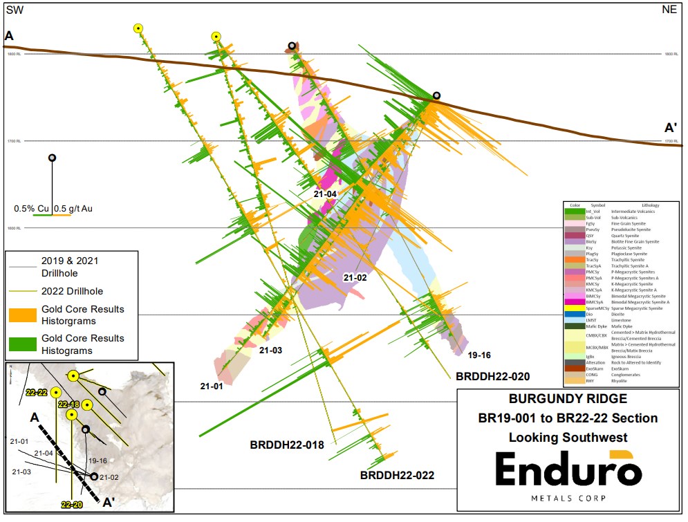
Figure 2: Cross-section of select 2019, 2021 and 2022 drill holes with grade histograms and the lithology layer from recent geological modelling efforts.
To view an enhanced version of this graphic, please visit:
https://images.newsfilecorp.com/files/6406/167260_78caf2f49487b987_003full.jpg
Cole Evans, CEO of Enduro Metals commented, "Our completion of the inaugural geological model is a significant milestone for our team, as it provides crucial insights into the factors driving mineralization at Burgundy, and the underlying geological processes that have led to the formation of this system. With this knowledge in hand, we are now equipped to target similar mineralization patterns and identify additional prospective areas along the Copper Line, such as 72' Zone, North Toe, and other areas of interest. Our commitment to scientific rigor and our focus on understanding the geological drivers of mineralization are key to our success. We are excited about the possibilities that lie ahead as we continue to unlock the full mineral potential of the Newmont Lake Project."
Geological Discussion
Methodology
The geological model was undertaken with a methodical and systematic approach to classify the paragenesis and relationships between lithology, alteration, mineralization, and structural events over an area approximately 1500m long x 500m wide. A total of 12,783 meters of drill core was relogged in detail over the past four months to complete this model. The process involved visually relogging core guided by reference to the Company's robust multi-element geochemistry suite and geochemical data analysis software to delineate the unique lithologies, alteration types, and structures present at Burgundy. Hyperspectral point data was taken simultaneously to complete the data collection effort. Following this, a series of hand drawn cross-sections and level plans were completed which were scanned, georeferenced, and digitized for use in geological modeling software.

To view an enhanced version of this graphic, please visit:
https://images.newsfilecorp.com/files/6406/167260_78caf2f49487b987_004full.jpg

To view an enhanced version of this graphic, please visit:
https://images.newsfilecorp.com/files/6406/167260_78caf2f49487b987_005full.jpg
Lithological
The Burgundy system's intrusive complex is interpreted as a series of igneous intrusions, ranging from syenitic to monzonitic in composition, that intrude a calcareous volcano-sedimentary sequence with adjacent 150m - 200m thick limestone horizons thought to be associated with either upper Stikine to lower Stuhini volcanic assemblages. Using specific immobile trace element ratios (ex. Al/Ti, Zr/Ti, V/Sc, Sc/Zr, Nb/Zr, Nb/Y) the lithological units were classified and defined into over 30 unique units. Cross-cutting relationships were analyzed in detail and an interpretive timeline of lithological events was created (see Fig. 3). The earliest intrusions include visually striking megacrystic dykes with variable internal textures ranging from sparsely porphyritic to crowded trachytic. These intrusions appear to pre-date the hydrothermal alteration and mineralization at Burgundy. Following the emplacement of the pre-mineral intrusions, a mafic event occurred which may have contributed to a recharge of the system; a common event, seen in many world-class porphyry systems around the world. In the more distal parts of the system, a grade-destructive, matrix rich breccia obliterates much of the original protoliths. Several fine-grained intrusions emplace shortly after the mafic event. These intrusions are interpreted to be part of a syn-mineral intrusive package which occurred at the same time as the calcic to calc-potassic hydrothermal alteration events. An intrusive breccia also occurs within this time frame with a compositionally syenite magmatic cement that can host a chalcopyrite-only sulphide assemblage. At the end of the timeline, a late megacrystic intrusion is documented that hosts very little alteration and may mark the end of the hydrothermal porphyry sequence.

Figure 3: Timeline of the lithological and hydrothermal paragenesis of the Burgundy Ridge system.
To view an enhanced version of this graphic, please visit:
https://images.newsfilecorp.com/files/6406/167260_78caf2f49487b987_006full.jpg
Alteration
As part of the core relogging program, hyperspectral measurements were collected at every meter using a TerraSpec Halo device. Metadata was collected from each measurement documenting what feature was selected, allowing for the separation of vein, breccia, and pervasively hosted mineralization. Seven alteration assemblages were defined according to the equilibrium assemblages of hydrothermal silicates and carbonate minerals observed in the drill core. Zoning from proximal to distal they include calc-potassic, calcic, calc-sodic, silicification, propylitic, illite-white mica, and iron-carbonate (Wilson, 2019). Sulphide assemblages were classified independently of the alteration phases to establish sulphide zonation. Interpretation suggests that there is an overlap in the sulphide zonation and prospectivity of alteration phases encountered at different areas of Burgundy. The strongest alteration and mineralization intersected thus far at Burgundy occurs towards the southwest. Calc-potassic breccias and generally chalcopyrite-dominant sulphide assemblages are traceable for over 250m down-dip. The vertical extent is unknown at this time. To the northeast, more distal assemblages are noted as calcic breccias and skarns with pyrite dominant sulphide assemblages. Chalcopyrite>pyrite occurs sporadically through skarn zones, veins, and within some calcic breccias.
Mineralization
Copper sulphide mineralization is predominantly observed in the form of chalcopyrite and can range from breccia fill to semi-massive replacement zones. At surface and within structures, copper oxides and chalcocite are common. Pyrite is widely distributed through the system and can range from mm-scale fracture fillings to semi-massive replacement zones.

Figure 4: Sample B0024679 from 144.69m to 145.5m of BR19-16 assaying 1.88% Cu, 1.02 g/t Au, 37.24 g/t Ag, and 0.67% Zn. This sample represents a calc-potassic hydrothermal breccia of cpy>py at the Ridge Zone.
To view an enhanced version of this graphic, please visit:
https://images.newsfilecorp.com/files/6406/167260_78caf2f49487b987_007full.jpg

Figure 5: Sample B0024254 from 171.85m to 172.42m of BR19-13 assaying 8.98% Cu, 0.62 g/t Au, 35.97 g/t Ag, and 2.36% Zn. This sample represents semi-massive, chalcopyrite-dominant mineralization at the Ridge Zone.
To view an enhanced version of this graphic, please visit:
https://images.newsfilecorp.com/files/6406/167260_78caf2f49487b987_008full.jpg
Structure
A key aspect of the data collection phase focused on the comprehensive analysis Burgundy's structural features, particularly highlighting their impact on mineralization. Significantly, a prominent thrust fault exhibiting large-scale displacement was identified in BR22-17, 19, and 21. Immediately after the fault, volcanic packages with propylitic alteration assemblages were intersected, a notable distinction from the calcic to calc-potassic assemblages observed above the fault. When traced to surface the structure is interpreted to run NE-SW, providing valuable insights for further exploration efforts along the Copper Line and improving our understanding of Newmont Lake's porphyry potential.

Figure 6: Image of Cross-Section interpretation from winter geological modeling project with drill traces.s
To view an enhanced version of this graphic, please visit:
https://images.newsfilecorp.com/files/6406/167260_picture1.png
The Copper Line - Exploration Update
Enduro Metals continues to generate high priority exploration targets along the Copper Line. The Copper Line represents a complex series of trans-arc geological structures observed over a 20km NE-SW corridor, believed to have substantial control and implications on mineralization within the entire western portion of the Newmont Lake Project. The structural setting closely resembles that seen at Galore Creek and KSM, located to the northwest and southeast of the Newmont Lake Project respectively. Of particular interest are two targets located at either end of the Copper Line.
The first area of interest was identified from review of an assessment report filed by Ticker Tape Resources Ltd in October 1988 (https://apps.nrs.gov.bc.ca/pub/aris/Detail/18129). The report was primarily concerned with Ticker Tape's work on the North Zone, the South Zone, and the King Vein prospects located to the south of the Newmont Lake Property. However, under Ticker Tape's prospecting activities it was noted that "in the northwest corner of the Ice 10 claim, north-south trending quartz and carbonate veins 2 to 10cm wide carry 28.39 oz/t silver, 21.5% copper and 4.72 oz/t silver, 1.73% copper (sample numbers 24869, 24875). The narrow veins are closely spaced and a sample of the alteration zone around these indicated 3.6 oz/t silver and 2% copper." The Ice 10 claim lies within the current Newmont Lake property boundary, at the southern end of the Copper Line. Sample 24869 represents the highest-grade Copper sample reported to date on the Newmont Lake property, and is described as a quartz vein containing malachite, azurite, and bornite.
Review of satellite imagery at the location from where these samples were taken shows an approximate 2,000m x 850m gossanous zone to the west of a substantial structural feature, previously covered by ice and permanent snow. Mineralization in this area is concentrated immediately east of the Copper Line. This pattern is also noted at Burgundy and the 72' Zone, located 5km and 7km to the northeast respectively.
The second target of interest lies to the northeast of the recently discovered North Toe prospect (see announcement dated 11 April 2023) and is referred to as the Orange Prospect. Orange is a 500m x 500m gossanous area. Early observations suggest that Orange may be at a structural convergent point between the Copper Line and the Chachi Corridor. Early geochemical and mineralogical evidence at Orange is consistent with a potential intermediate-sulphidation epithermal system. Copper/Silver mineralization is typified by tennantite - tetrahedrite, enargite, and chalcocite, along with associated secondary minerals such as malachite, azurite, and chrysocolla. Locally, semi-massive sphalerite, galena, pyrite, and chalcopyrite are hosted in outcropping in a series of quartz veins ranging from 15cm to 50cm thick on the southern margins of Orange. The target has excellent accessibility as it is located 12km along a flat valley from the Galore Creek Mine Road. Recent glacial retreat (see Figure 7) has exposed this area which has never seen historic sampling. Mineralization has been sampled right to the edge of the moraine and rock flour left behind by the receding glacier, leaving the likelihood that the anomalous area is larger than 500m x 500m.

Figure 7: Plan view map of Orange - an approx. 500m x 500m area of gossanous material proximal to the northeast end of the Copper Line. Mineralogical and geochemical interpretations of initial prospecting samples collected by Enduro Metals are suggestive of a potential intermediate-sulphidation epithermal-like system at an apparent double junction between the Copper Line fault system and the Chachi Corridor. Follow-up work is required to confirm this hypothesis.
To view an enhanced version of this graphic, please visit:
https://images.newsfilecorp.com/files/6406/167260_78caf2f49487b987_011full.jpg
Citations:
Wilson, A.J., 2019, Ridge Zone, Newmont Lake Project, British Columbia, Canada: Drill core review and exploration recommendations for Burgundy Ridge and 72 Zone. Internal Report, Enduro Metals Corporation, Kelowna, British Columbia.
Wilson, A.J., 2022, Assessment of the porphyry Cu-Au exploration potential of the Newmont Lake property, NW British Columbia, Canada, with special emphasis on the Burgundy Ridge alkalic porphyry prospect. Internal Report, Enduro Metals Corporation, Kelowna, British Columbia.
Qualified Person
The technical information in this news release has been reviewed and approved by Mr. Maurizio Napoli, P. Geo., Director for Enduro Metals, a Qualified Person responsible for the scientific and technical information contained herein under National Instrument 43-101 standards.
About Enduro Metals
Enduro Metals is an exploration company focused on it's flagship Newmont Lake Project; a total 688km2 property located between Eskay Creek, Snip, and Galore Creek within the heart of northwestern British Columbia's Golden Triangle. Building on prior results, the Company's geological team have outlined 4 deposit environments of interest across the Newmont Lake Project including high-grade epithermal/skarn gold along the McLymont Fault, copper-gold alkalic porphyry mineralization at Burgundy & 72 Zones, encouraging porphyry-style alteration typical of alkalic copper-gold porphyry systems at North Toe, and a large 9km x 4km geochemical anomaly hosting various gold, silver, copper, zinc, nickel, cobalt, and lead mineralization along the newly discovered Chachi Corridor.
On Behalf of the Board of Directors,
ENDURO METALS CORPORATION
"Cole Evans"
Chief Executive Officer
For further information please contact:
Ali Wasiliew - Manager of Communications
Tel: + (236) 420-4050
Email: [email protected]
Sean Kingsley - Director of Communications
Tel: +1 (604) 440-8474
Email: [email protected]
https://www.endurometals.com
As a continued effort to keep investors, interested parties and stakeholders updated, we have several communication initiatives. If you have any questions online (Twitter, Facebook, LinkedIn, or Instagram) feel free to send direct messages or a post and include the hashtag #askENDR.
To book a one-on-one 30-minute Zoom video call directly click here: https://endurometals.youcanbook.me
Neither the TSX Venture Exchange nor its Regulation Services Provider accepts responsibility for the adequacy or accuracy of this release.
Forward-Looking Statements
This news release contains statements that constitute "forward-looking statements". Such forward looking statements involve known and unknown risks, uncertainties and other factors that may cause Enduro's actual results, performance or achievements, or developments in the industry to differ materially from the anticipated results, performance or achievements expressed or implied by such forward-looking statements. Forward looking statements are statements that are not historical facts and are generally, but not always, identified by the words "expects," "plans," "anticipates," "believes," "intends," "estimates," "projects," "potential" and similar expressions, or that events or conditions "will," "would," "may," "could" or "should" occur.
Although Enduro believes the forward-looking information contained in this news release is reasonable based on information available on the date hereof, by their nature forward-looking statements involve assumptions, known and unknown risks, uncertainties and other factors which may cause our actual results, performance or achievements, or other future events, to be materially different from any future results, performance or achievements expressed or implied by such forward-looking statements.
The forward-looking information contained in this news release represents the expectations of the Company as of the date of this news release and, accordingly, is subject to change after such date. Readers should not place undue importance on forward-looking information and should not rely upon this information as of any other date. While the Company may elect to, it does not undertake to update this information at any particular time except as required in accordance with applicable laws.

To view the source version of this press release, please visit https://www.newsfilecorp.com/release/167260